A.B.C Topographical Maps - NSW
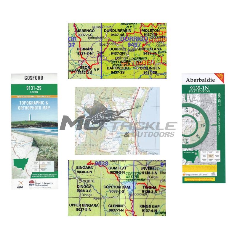
These topographical maps are used for Walking, 4WD, all forms of recreation and show Major Roads, Secondary Roads, Dirt Tracks, Walking Tracks. Rivers, Lakes, Creeks and Dams. The heights of hills above sea level and how steep the mountains or valleys are.
| Giftware Size | Size |
|---|---|
| Moonee Beach 9537-4S | Moonee Beach 9537-4S |
| Bellingen 9437-2S | Bellingen 9437-2S |
| Woolgoolga 9537-4N | Woolgoolga 9537-4N |
| Grafton 9438-1S | Grafton 9438-1S |
| Buccarumbi 9438-3N | Buccarumbi 9438-3N |
| Nymboida 9438-3S | Nymboida 9438-3S |
| Korogoro Point | Korogoro Point |
| Hyatts Flat 9336-1N | Hyatts Flat 9336-1N |
| Willi Willi 9336-2S | Willi Willi 9336-2S |
| Chaelundi 9337-1N | Chaelundi 9337-1N |
| Ebor 9337-2S | Ebor 9337-2S |
| Kempsey 9435-1N | Kempsey 9435-1N |
| Moleton 9437-1S | Moleton 9437-1S |
| Dorrigo 9437-3N | Dorrigo 9437-3N |
| Darkwood 9437-3S | Darkwood 9437-3S |
| Clybucca 9436-2S | Clybucca 9436-2S |
| Dundurrabin 9437-4S | Dundurrabin 9437-4S |
| Coutts Crossing 9438-2N | Coutts Crossing 9438-2N |
| Jackadgery 9438-4N | Jackadgery 9438-4N |
| Coffs Harbour 9537-3N | Coffs Harbour 9537-3N |
| Yamba 9539-2S | Yamba 9539-2S |
| Maclean 9539-3S | Maclean 9539-3S |
| Raleigh 9537-3S | Raleigh 9537-3S |
| Red Rock 9538-3S | Red Rock 9538-3S |
| Tucabia 9538-4S | Tucabia 9538-4S |
| Brooklana 9437-2N | Brooklana 9437-2N |
| Glenreagh 9437-1N | Glenreagh 9437-1N |
| Quipolly 9035-3S | Quipolly 9035-3S |
| Glenrock 9134-1S | Glenrock 9134-1S |
| Weabonga 9135-1S | Weabonga 9135-1S |
| Chimneys Ridge | Chimneys Ridge |
| Gungal | Gungal |
| Bargo | Bargo |
| Woolomin 91351-N | Woolomin 91351-N |
| Macksville 9436-1S | Macksville 9436-1S |
| Byron Bay | Byron Bay |
| Rock Hill | Rock Hill |
| Niangala | Niangala |
| Lyndhurt | Lyndhurt |
| Tantangara | Tantangara |
| Cowra Creek | Cowra Creek |
| Esmeralda 7640 | Esmeralda 7640 |
| Yambulla | Yambulla |
| Dalmorton 1:25000 | Dalmorton 1:25000 |
These topographical maps are used for Walking, 4WD, all forms of recreation and show Major Roads, Secondary Roads, Dirt Tracks, Walking Tracks. Rivers, Lakes, Creeks and Dams. The heights of hills above sea level and how steep the mountains or valleys are.
New South Wales is covered by 3 scales of topographical maps, 1-25,000, 1-50,000 and 1-100,000. The 1-25,000 which is the most detailed covers the coast, 1-50,000 through the middle of NSW and the 1-100,000 Central and Western NSW . These topographical maps are used for Walking, 4WD, all forms of recreation and show Major Roads, Secondary Roads, Dirt Tracks, Walking Tracks. Rivers, Lakes, Creeks and Dams. The heights of hills above sea level and how steep the mountains or valleys are. National Parks, State Forests, Lookouts, Gold Diggings points of interest are also shown.